


- What is LiDAR?
- The Annotation Challenge Nobody Talks About
- Why Traditional Computer Vision Falls Short
- The Real Cost of Poor Annotation
- How Macgence Solves the LiDAR Annotation Challenge
- Why Product Managers and CTOs Choose Macgence
- The Technical Edge: What We Annotate
- Real-World Impact
- Moving Forward with Confidence
- Partner With Experts Who Understand Your Vision
Why Your Self-Driving Car Needs Perfect Vision: The LiDAR Annotation Story
Imagine you’re driving down a busy street. Your eyes are constantly scanning – pedestrians crossing, cars merging, cyclists weaving through traffic. Now imagine teaching a machine to do the same thing, except it doesn’t have eyes. It has lasers. And those lasers need to understand what they’re “seeing.”
We’ve seen many product launches that aim to automate your driving experience; most of them are failing on the product launch. After investing millions, not getting the expected results is frustrating, and after digging deep. The real reason for failing? Data.
The truth is, real-world data is messy, expensive to collect, and full of edge cases you can’t possibly capture all at once. For something as critical as an autonomous vehicle, you can’t afford to have blind spots in your data. A single missed pedestrian or a misidentified lane marking can have catastrophic consequences. This is where the conversation shifts from just collecting more data to creating smarter data.
At Macgence, we’ve built our reputation on bridging this gap. We don’t just annotate data; we build the foundational datasets that make autonomous systems reliable. We specialize in Lidar Annotation for Autonomous Vehicles, turning raw, chaotic 3D point clouds into structured, intelligent information that your models can actually learn from. And when real-world data isn’t enough, we turn to the next frontier: synthetic data.
This isn’t just about labeling. It’s about creating a data strategy that anticipates your model’s needs and scales with your ambitions. Let’s dive into why this is so critical.
What is LiDAR?
LiDAR stands for Light Detection and Ranging. Think of it as giving your autonomous vehicle the ability to “see” in 3D using laser pulses instead of visible light. While cameras give you pretty pictures, LiDAR gives you precise spatial data – the exact distance, shape, and position of everything around your vehicle.
Here’s what makes LiDAR special for autonomous driving:
- It works in low light and even complete darkness
- Rain doesn’t blind it like it does cameras
- It provides millimeter-level accuracy for distance measurements
- It creates detailed 3D point clouds of the environment
Modern LiDAR systems can emit up to 500,000 laser pulses per second. That’s an insane amount of data – and every single pulse creates a data point that needs to be understood and labeled correctly.
The Annotation Challenge Nobody Talks About
Here’s where things get interesting. Raw LiDAR data is just millions of points floating in 3D space. Your autonomous system sees these points but doesn’t inherently know what they represent. Is that cluster of points a pedestrian? A parked car? A trash can? A cyclist about to turn left?
This is where LiDAR annotation for autonomous vehicles becomes absolutely critical. Someone – or something – needs to label each object in those point clouds so machine learning models can learn to recognize them.
The challenge is real:
- Volume: A single autonomous vehicle can generate terabytes of LiDAR data daily
- Complexity: Unlike 2D images, you’re annotating in three dimensions
- Precision: Small errors in annotation can lead to catastrophic failures in real-world scenarios
- Edge cases: Unusual objects or scenarios need special attention
According to recent industry data, improving annotation accuracy by just 5% can lead to a 20% increase in object recognition accuracy. That’s not a small deal when lives are on the line.
Why Traditional Computer Vision Falls Short
You might be wondering – can’t we just use regular cameras and call it a day? Some companies have tried that approach, but there’s a reason why most serious autonomous vehicle programs invest heavily in LiDAR.
Cameras struggle with:
- Depth perception (they’re inherently 2D)
- Variable lighting conditions
- Weather interference
- Distinguishing objects at different distances
LiDAR solves these problems, but only if the training data is properly annotated. The annotated LiDAR data helps autonomous systems understand not just what an object is, but precisely where it is in 3D space and how it’s moving.
Key Applications of LiDAR Annotation
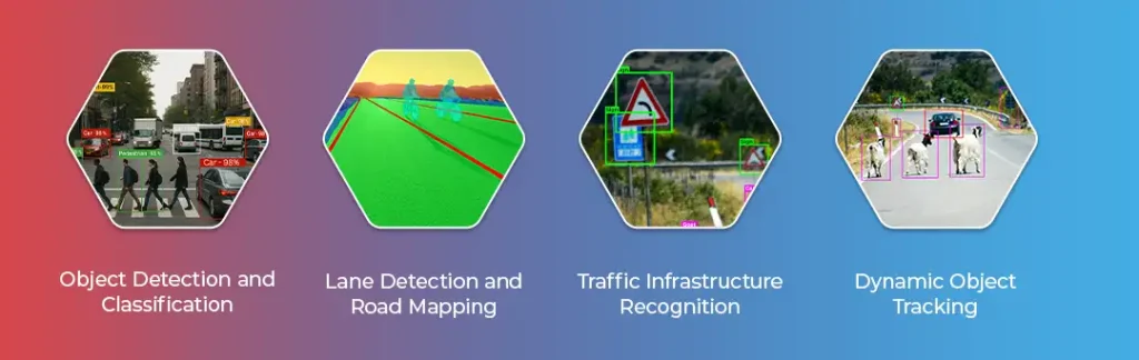
When we work on LiDAR annotation for autonomous vehicles, we’re typically focusing on several critical tasks:
- Object Detection and Classification: Every vehicle, pedestrian, cyclist, and obstacle needs to be identified and classified. This isn’t just about drawing boxes – it’s about understanding object behavior and predicting movement patterns.
- Lane Detection and Road Mapping: Autonomous vehicles need to know where they can and can’t drive. LiDAR annotation helps define lane boundaries, road edges, and drivable surfaces with precision.
- Traffic Infrastructure Recognition: Stop signs, traffic lights, road barriers – all of these need to be accurately labeled so your vehicle knows how to respond appropriately.
- Dynamic Object Tracking: It’s not enough to detect objects once. The system needs to track them frame by frame, understanding their velocity and trajectory to predict future positions.
The Real Cost of Poor Annotation
I’ve seen projects fail because teams underestimated the importance of high-quality annotation. Here’s what happens:
- False positives: The vehicle “sees” obstacles that aren’t there, leading to unnecessary braking and a poor user experience
- False negatives: Even more dangerous – missing real obstacles that could cause accidents
- Training inefficiencies: Poor data quality means models need more training time and still perform worse
- Regulatory delays: Safety certifications require proven performance across diverse scenarios
Research from MIT shows that properly annotated LiDAR data can reduce false positives in object detection by 20%. In the autonomous vehicle world, that’s massive.
How Macgence Solves the LiDAR Annotation Challenge
This is where I’ve seen real transformation happen. At Macgence, we’ve developed specialized approaches to tackle the unique challenges of LiDAR annotation for autonomous vehicles.
Our Approach to 3D Point Cloud Annotation
We don’t just label objects – we understand context. Our team uses advanced machine learning algorithms combined with human expertise to ensure every annotation is accurate and meaningful. This includes:
Precise 3D Bounding Boxes: We create three-dimensional boxes that capture the exact size, orientation, and position of objects in the point cloud. This level of detail is crucial for autonomous systems to make split-second decisions.
Semantic Segmentation: Beyond simple boxes, we label individual points within the cloud, allowing for pixel-perfect understanding of complex objects and scenarios.
Temporal Annotation: Objects don’t exist in isolation – they move. We track objects across multiple frames, providing temporal context that helps autonomous systems predict behavior.
Quality That Makes the Difference
What sets our LiDAR annotation services apart is our commitment to accuracy. We employ:
- Multi-layer validation: Every annotation goes through multiple quality checks
- Domain expertise: Our annotators understand automotive scenarios, not just data labeling
- Scalability: Whether you need thousands or millions of frames annotated, we can scale
- Edge case handling: We pay special attention to unusual scenarios that are critical for safety
Why Product Managers and CTOs Choose Macgence
If you’re building autonomous systems, your data quality directly impacts your product’s success. Here’s what I’ve learned matters most to technical leaders:
- Speed to Market
Time is money, especially in the competitive autonomous vehicle space. Our efficient annotation workflows and AI-assisted tools help you process massive datasets quickly without sacrificing quality.
- Regulatory Compliance
Autonomous vehicle systems face intense scrutiny. Our annotation services meet industry standards and provide the documentation needed for safety certifications.
- Cost Efficiency
Building an in-house annotation team is expensive and time-consuming. We provide expert annotation services at scale, letting your team focus on what they do best – building great autonomous systems.
- Flexibility and Customization
Every autonomous vehicle project is unique. We work with you to understand your specific requirements and adapt our annotation workflows accordingly.
The Technical Edge: What We Annotate
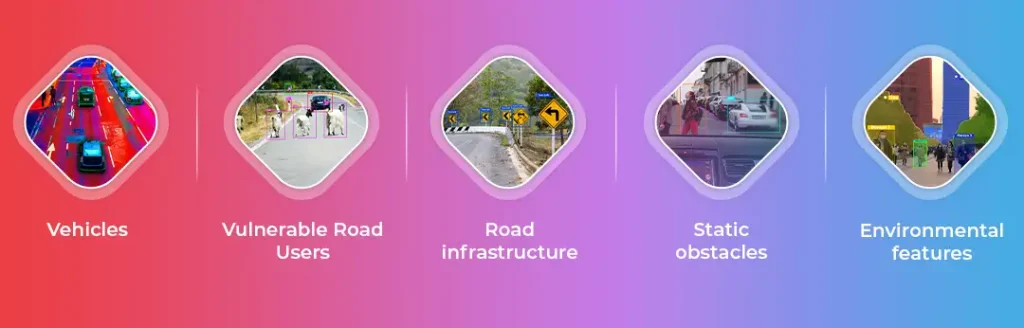
Our LiDAR annotation services cover the full spectrum of autonomous vehicle needs:
- Vehicles: Cars, trucks, motorcycles, buses – every type of vehicle on the road
- Vulnerable road users: Pedestrians, cyclists, people using mobility devices
- Road infrastructure: Signs, signals, barriers, lane markings
- Static obstacles: Parked vehicles, construction equipment, debris
- Environmental features: Curbs, vegetation, buildings, terrain
We understand that autonomous vehicles need to handle Level 5 autonomy eventually – perfect perception across every scenario. That’s why we’re meticulous about annotating diverse datasets across different:
- Geographic locations
- Weather conditions
- Traffic densities
- Time of day
- Edge cases and unusual scenarios
Real-World Impact
The autonomous vehicle market is growing rapidly. Industry projections show that by 2030, nearly 12% of vehicles on the road will have Level 3 or higher autonomy. Every one of these vehicles relies on properly annotated LiDAR data.
We’ve worked with companies developing:
- Robotaxis for urban transportation
- Autonomous delivery vehicles
- ADAS systems for consumer vehicles
- Industrial autonomous vehicles
- Agricultural automation
Moving Forward with Confidence
Building autonomous vehicles isn’t easy. The technology is complex, the stakes are high, and the competition is fierce. But with the right data annotation partner, you can accelerate your development while ensuring safety and reliability.
At Macgence, we’ve processed millions of LiDAR frames for autonomous vehicle projects. We understand the technical challenges, the safety requirements, and what it takes to bring autonomous systems to market.
Partner With Experts Who Understand Your Vision
If you’re a product manager trying to hit aggressive timelines, a CTO evaluating data annotation options, or a data scientist frustrated with poor-quality training data – we get it. We’ve been there.
LiDAR annotation for autonomous vehicles isn’t just about labeling data. It’s about enabling the future of transportation. It’s about building systems that people trust with their lives.
Let’s talk about how Macgence can accelerate your autonomous vehicle development. Our team of annotation specialists, domain experts, and AI engineers is ready to help you transform raw LiDAR data into the high-quality training datasets your models deserve.
Contact us today and let’s build safer, smarter autonomous vehicles together. Because the future of transportation deserves nothing less than perfect perception.
Ready to elevate your autonomous vehicle project? Get in touch with Macgence for expert LiDAR annotation services tailored to your specific needs.

You Might Like

October 11, 2025
Why Your AI Can’t Understand Humans: The Multimodal Conversations Datasets Gap
Your conversational AI is failing, and you probably don’t know why. It responds to words perfectly. The grammar checks out. The speed is impressive. But somehow, it keeps missing what users actually mean. The frustrated customers. The sarcastic feedback. The urgent requests are buried in casual language. Here’s what’s really happening: your AI is reading […]

October 9, 2025
What is Synthetic Datasets? Is it real data or fake?
Picture this: You’re building the next breakthrough AI product. Your models need millions of data points to learn. But there’s a problem. You can’t access enough real-world data due to various factors, such as compliance issues, security factors, and specific needs. Privacy regulations block you. Collection costs are sky-high. And even when you get data, […]

October 6, 2025
What Are the Most User-Friendly Geospatial AI Solutions?
Finding the correct geospatial AI platform should not feel like navigating a maze. Yet, for product managers and CTOs, choosing solutions that strike a balance between power and usability often becomes the biggest challenge in deploying location-based intelligence. The geospatial AI market is estimated to reach $2.3 billion by 2027, but here’s the one thing: […]