Today’s world is data-based, where Geographic Information Systems (GIS) have a significant role in managing and analyzing spatial issues. Effective GIS Data Management is crucial for organizations that depend on accurate and up-to-date geographical information to make informed decisions. Macgence is a leader in the provision of GIS solutions and we provide comprehensive services in respect to GIS data management which guarantees integrity, accuracy, and accessibility of your geospatial data.
What does GIS Data Management Entail?
GIS data management refers to the procedures as well as technologies employed for storing, organizing, maintaining, and accessing geographic details. This includes several activities such as collection of facts about locations, storage of these facts, integration of different sets together by comparison among others. In summary therefore effective GIS data management makes sure that spatial statistics are reliable and precise ready for analysis and decision-making.
Key Components of GIS Data Management
Data Collection: Prerequisite to any good gis database management system is obtaining pertinent geospatial statistics (Bolstad 2012). Satellite imagery, aerial photography field surveys or Gps enabled devices are some of the sources where this type of information can be generated from.
Data Storage: Proper storage is important if the integrity of geospatial data would be maintained as well as its accessibility. Often referred to as databases; they manage large volumes describing their contents through complex queries or analysis procedures when necessary.
Data Integration: Many times while dealing with gis database management one needs to integrate data from other sources. This procedure allows for effective utilization between dissimilar datasets thus providing an overall picture regarding an area underscout.
Data Quality Control: The importance of assuring accuracy pertaining to gis databases cannot be stressed enough (Olofsson et al., 2009). Validating these records for authenticity ensures that no mistake remains unattended within them hence making them both reliable and precise.
Data Dissemination: Making the information available to users is one of the most fundamental aspects of data management. Here one may have to make maps, reports or visualization tools such as Google Earth among others thus providing access to this information through GIS software and web portals.
Why Macgence for GIS Data Management?
Macgence has been providing GIS data management services that are tailored to suit our clients’ specific needs since time immemorial. There are reasons why you should choose us as your suitable partner in management of your GIS data:
Expertise and Experience: Our team comprises professionals with wide knowledge in GIS who bring a wealth of expertise gained over many years. We ensure effective and efficient database administration by using these technologies together with best practices based on geospatial principles.
Advanced Technology: Macgence utilizes cutting-edge geographical information systems which facilitate modernized methods towards managing related data. For instance, we use sophisticated software applications to store this type of statistical information accurately while anyone concerned processes or accesses it.
Customized Solutions: Notably every organization has its own particular need for Gis database management facilities (Diamantini et al., 2011). We therefore offer tailor-made products able to cater for your exacting demands whether they involve systematizing records used during town planning schemes or ones employed when making informed decisions about issues pertaining to the environment.
Comprehensive Services: Macgence offers an entire range of gis database services from collecting information up until its withdrawal into final form complete quality control programs. Therefore that’s the reason we tend to cover all aspects concerning what you might need for managing any type of data today rather than just partial ones.
Commitment to Quality: The most important thing at Macgence is quality that is exactly what we focus on (Zhao et al., 2012). To ensure that our GIS databases are reliable and accurate, we subject them to very strict quality control measures.
Benefits of Effective GIS Data Management
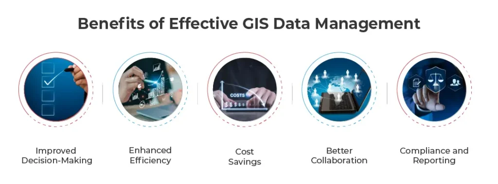
There are many benefits to deploying effective GIS data management, including:
Improved Decision-Making: Making accurate and reliable GIS data available is a prerequisite for informed decision making. Organizations can analyze spatial information to identify trends, make predictions, and create plans.
Enhanced Efficiency: Efficient handling of geospatial information in the data management process cuts down the duration required to access and analyze the data.
Cost Savings: By minimizing errors or discrepancies in data, organizations can avoid costly mistakes as well as enhance their overall efficiency.
Better Collaboration: Good GIS data management makes it possible to have one source where all users can access and share geospatial information easily.
Compliance and Reporting: For regulatory compliance purposes, organizations must use accurate GIS Data when producing reports or documentation.
Applications of GIS Data Management
GIS Data Management is widely used across various industries. Some major areas where GIS data management plays a significant role are:
Urban Planning: Geographical Information System (GIS) is essential for urban planning purposes. Planners use geospatial data to study land utilization, infrastructure, population distribution patterns and other environmental aspects that enable them in coming up with informed decisions regarding city development.
Environmental Monitoring: The Environmental agencies utilize GIS data sources in order to monitor natural resources as well as track wildlife populations among others while assessing changes that occur within these environments. It ensures that effective management of these facts provides correct information at any particular time during conservation or sustainability initiatives.
3.Transportation and Logistics: Good GIS database management practices support the optimization of transportation routes and logistics operations. Accurate spatial data helps firms cut travel time and costs while improving overall efficiencies across companies, such as shipping companies and others.
4.Disaster Management: GIS Data is critical for disaster preparedness.Government uses G.I.S.to map hazard zones such as earthquakes,vulcanicity,landslides and so forth,governments employ geospatial information to track the spread of natural disaster and emergency response coordination.
5.Real Estate: GIS data management is useful in analyzing property values, tracking market trends as well as making informed decisions on real estate investments.
How Macgence Leads in GIS Data Management
Macgence is a leading provider of GIS data management solutions that yield success for our customers. Here are few key ways we make a difference:
Data Collection and Processing: We utilize advanced tools and techniques to gather and process high-quality geospatial data. Our team ensures that the data is accurate, relevant, and ready for analysis.
Database Management: The company creates robust GIS databases which can accommodate vast amounts of spatially-based information. The developers designed these databases with performance optimization in mind so that you can always access your data when you need it and keep it up to date.
3.Data Integration and Analysis: We use multiple sources to provide you with a comprehensive view of your area of interest by integrating this information into one set. Our sophisticated analysis tools allow you to find patterns, identify trends, or make other types of use out of such an input.
4.Quality Control and Assurance: Our processes are based on quality throughout the management of gis database.Our strict quality control procedures ensure accuracy through data cleaning activities carried out during several stages
5.Visualization and Reporting: We deliver detailed maps, reports, visualizations, etc., making all the geo-information easy for users to understand. These solutions help present information clearly.
Conclusion
Decision making in organizations that use geospatial information effectively critically depends on efficient GIS data management. Macgence is the best choice due to availability of extensive geographic information systems management services that support data integrity, accuracy and accessibility. You can trust the company for any enterprise with GIS needs because of its capabilities, technology, and commitment to quality. Please contact us for further details about these products and ways by which they can facilitate your work with spatial data.
FAQs
Ans: – Key challenges in GIS data management include ensuring data accuracy and consistency, managing large volumes of data, integrating data from multiple sources, and maintaining data quality over time. Effective GIS data management practices and the use of advanced technologies can help address these challenges.
Ans: – Organizations benefit from GIS data management by gaining access to accurate and reliable geospatial information, which supports informed decision-making, enhances efficiency, reduces costs, and improves collaboration. Effective data management also ensures compliance with regulatory requirements and supports reporting and documentation efforts.
Ans: – Technologies used in GIS data management include Geographic Information Systems (GIS) software, databases, remote sensing tools, GPS devices, and data integration and analysis tools. These technologies enable the collection, storage, processing, integration, and dissemination of geospatial data.
Macgence is a leading AI training data company at the forefront of providing exceptional human-in-the-loop solutions to make AI better. We specialize in offering fully managed AI/ML data solutions, catering to the evolving needs of businesses across industries. With a strong commitment to responsibility and sincerity, we have established ourselves as a trusted partner for organizations seeking advanced automation solutions.


